The GeoRSS Model is a way to link geographical information with web content without imposing restrictions on the content’s type or format. It’s essentially a set of rules for describing locations using simple shapes and coordinates, and it can be applied to any kind of digital content.
At its core, GeoRSS is defined within its own namespace, “georss:”, but it’s designed to be flexible, allowing for integration with elements from other namespaces. The structure of GeoRSS is conceptual and needs to be translated into a specific format (like XML or RDF) for practical use. This translation is referred to as serialization, and GeoRSS supports multiple serialization methods to ensure compatibility across different platforms and systems.
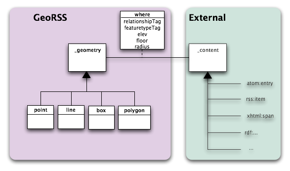
The fundamental elements of GeoRSS include:
- Coordinate Reference System (CRS): This is a predefined system used to specify geographical locations. GeoRSS adopts the WGS84 system, which is commonly used in GPS technologies. It uses latitude and longitude coordinates in decimal degrees. This system is essential because it provides a standardized way to describe locations on Earth, even though our planet doesn’t have actual grid lines.
- Geometry: GeoRSS uses simple shapes to represent locations:
- Point: A single set of latitude and longitude coordinates, representing a specific location.
- Line: A series of points connected in order, useful for representing routes or boundaries.
- Box: Defined by two coordinates, marking the southwest and northeast corners of a rectangular area. It’s useful for highlighting a specific region.
- Polygon: A closed shape made of four or more points, with the last point being the same as the first. It’s ideal for outlining irregular areas.
- 179 Degree Rule: To manage the Earth’s curvature and avoid ambiguous shapes, GeoRSS sets a limit on how far apart points in a line or polygon can be in terms of longitude. This rule ensures that shapes are represented accurately and clearly.
- Feature Type Tag and Relationship Tag: These are flexible tags meant to describe the nature of the geographical feature and its relationship to the web content. There are no strict rules for these tags, encouraging a natural development of categories and relationships.
- Elevation: GeoRSS also allows for the representation of elevation using two special tags for indicating height above sea level and the floor number within a building. This addition helps in providing a three-dimensional perspective to the geographical information.
In summary, the GeoRSS Model offers a versatile and straightforward method for associating web content with geographical data, using a mix of specific coordinates, simple geometrical shapes, and flexible tagging to describe real-world locations.